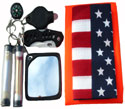
Compasses and Map Protractors
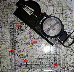
Like most experienced soldiers who served in an elite Airborne, Ranger or Special Forces unit. I, too, have spent my share of time in the boonies and know the difference between good & bad equipment. And if there's one piece of US military equipment that has always worked well for me and that was my trusty good ol'US military issued lensatic compass.
And no matter where I was deployed in the world, the jungle, desert, forest or in some ass deep snow, I knew I could always count on my US military lensatic compass to guide me and my soldiers to wherever we needed to go. It's a great compass, very accurate, durable and easy-to-use with just a little bit of practice.
|
 |
In fact, I am still using today the same military lensatic compass that was issued to me back in 1981 when I was a Platoon Sergeant in "C" Co. - 3rd Plt - 1st Battalion 509th Airborne Battalion Combat Team. But please don't tell Uncle Sam or the Army I still have it because I lied and told my supply sergeant I lost it when I really didn't. Yea, it may be a little bit beat up, but only because I've dropped it a few hundred times or more on the ground, but it still works great today. And nope, no way would I ever think of selling or trading it in for another one, no way!
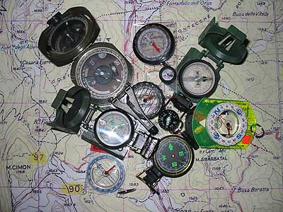
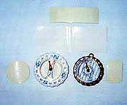
But it's not the only compass I have, I own dozen or so other types of compasses laying around the house somewhere. Some are commercial, some are military and some are military "styles" and "replicas." No, I didn't buy'em to use out in the field, I bought'em to figure out which ones are good, which ones are poor and which ones are bad and nothing but junk. Take a look at these compasses below and try to figure out which ones are the good military lensatic compasses and which ones are bad replicas.
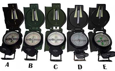
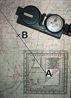
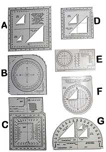
"A" is a Tritium, one of the first lensatic compasses to be issued to our troops in the 60's and can still be found in use in the military.
"B" is a Cammenga, a commercial made lensatic compass that meets DoD standards and is accepted for use by the US military.
"C" is a Stocker & Yale, another commercial made lensatic compass that meets DoD standards and is used today by the US military.
"D" is one of few commercial manufactured military lensatic "style" compasses that works fairly well but I wouldn't bet my life on it.
"E" is one of many poorly made commercial manufactured military lensatic "replicas" that are only good for determining the four basic cardinal directions of North, East, South and West and nothing more. These are the same type you'll find selling on eBay or at some flea market for a few bucks.
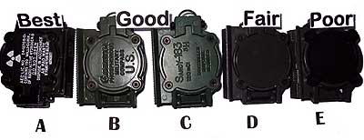
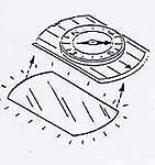
For a compass to meet Department of Defense (DoD) standards.. so it can be purchased and used by the US military and assigned a national stock number (NSN 6605-01-196-6971) so it can be ordered through the US military supply channels. It must: (a) be in a metal hinged aluminum case, (b) have an induction dampen needle that stops moving in 6 seconds or less, (c) contain no liquids, (d) has a thumb loop for stability, (e) a magnifying lens & sighting bracket for reading the dial in both degrees & mils, (f) and either phosphorescent painted markings requiring external light source or self-luminous markings requiring no external light source.
WARNING - BUYERS BEWARE! Don't be mislead by sellers trying to convince you their military "replica" or "style" compasses are just as good or better than a DOD approved military lensatic compass. They're full of shit! They might look pretty and seem reasonably priced, but if they're made in China, Russia or some other third world country and or they don't have the name of a reliable manufacturer stamped on it.... they are nothing but cheapass worthless imitations. I have purchased no less than a half dozen of these military lensatic replicas/styles on eBay and they all have one thing in common. The compass dials are off between 7 - 14 degrees or more. This may not sound like a lot, but if you plan to use one of these cheapass compasses with a topographic map, the further away you have to travel to get from Point "A" to "B" the further away you'll be off to the LEFT or RIGHT of your final destination.
In the military almost every experienced SFer, Ranger, and Infantry leader knows that it's almost impossible to stay precisely on an assigned "dead reckoning" compass heading/azmith. Therefore we have in the military what is called a 3 degree margin of error . Which means while using a compass you will most likely and unintentionally deviate 1 - 2 degrees off to the left or right of your compass azimute setting but you should still be able to arrive right on or close to your final destination. But when a compass [dial] is off by more than 3 degrees like most of these cheapass eBay military lensatic replicas/styles are... that's totally UNACCEPTABLE.
How can you determine if these compasses are way off or defected? The only way you can tell is by acquring a DOD approved military lensatic compass and then pick out a distant target like a tree and see what the azimute is in degrees from where you are standing to that tree. And then take the other compass and do the same thing, and if it's off by more than 3 degrees...then it's a defected compass and you should send it back to the seller and demand your money back.
And out of all the compasses manufactured throughout in the world, there is no doubt in my mind the standard issued US military lensatic compass is by far the most reliable and durable compass you can buy and own. Bar none! So if you're looking for a good compass that will get you to where you need to go and back home. You can't beat a good ol' DOD approved US military lensatic compasses with " NSN 6605-01-196-6971 " and or " Do Not Open - Controlled Disposal Required " stamped on it to prove it's the real McCoy and NOT some fake, replica or style.
Now a long time ago, back in 1996-97 when I was training the Bosnian Muslim Army, I had some problems training them in how to effectively use a US military lensatic compass. Why? Well because most of them have never used a compass in their lives, not even during the Bosnian war.
 |
Well after hours and hours of training they finally caught on how to use a compass and pretty good too. Except during the hours of darkness, at night. If they couldn't see something at a distance to sight their compasses on they just couldn't follow their compasses in a straight line. And the two "glow dots" that come with all military compasses just wasn't enough to help them navigate at night.
So what I did was take some cut up strips of glow tape and I glude them to the left and right side of the "sighting wire." And guess what? Yep, this little trick of mine seem to help them navigate better at night. What a difference a few thin pieces of glow tape can make, huh? |
 |
 |
And because we didn't have enough US military lensatic compasses to go around for everyone, I purchased a bunch of non-military compasses. But they didn't come with any illumination markings and therefore they were considered worthless for night training. Or so my fellow MPRI co-workers thought...
And so yep, again what I did was grab me some more glow tape, cut out the pattern and size that I needed and then attached them to the bottom of these "see-thru" compasses. And yep, you guessed it, worked out great. Hooah! |
 |
NOTE: Regardless of the type of compass you own, as long as the top and bottom of the compass is clear plastic or glass and you can see right through it. All you gotta do is attach a piece of glow tape underneath it so you can see the magnetic needle and you can then use it at night. Good idea? You betcha!
Now just to give you a "fast crash course" on how to use a compass.. (a) Place the compass in the palm of your hand (b) hold it level with the ground so the magnetic needle can move freely, (c) rotate the compass until the magnetic North seeking needle is directly in line with the letter "N" for north, (d) choose the direction you wish to travel in, (e) pick out a distinctive feature in that direction such as a tree, boulder, hill, etc, (f) look down at your compass to determine the azimuth (1-360 degrees) to that distinctive fearture and (g) start walking towards it. When you have arrived at that spot repeat these same steps over and over and over again until you arrive at your final destination. And there you go, that's how you use a compass. |
  |
 |
To use a protractor you first need to know what's a topographic map. Which is... a portion of the earth's surface as seen from above and drawn to scale on a piece of paper using colors, symbols and lines. To learn more about maps, and how to use'em I suggest you log onto this FREE online map reading manual below.
|

http://www.map-reading.com |
|
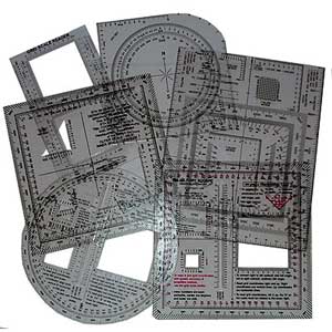
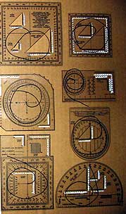
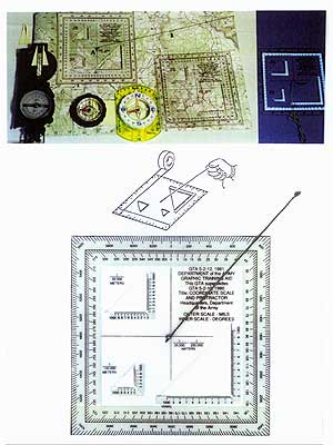
Now that you know what a topographic map is, here's what a protractor is... It's a tool designed to help you to quickly and accurately locate a point on a map with less chance of making any mistakes. They're also known as "map coordinate scales" too. And there are two types, military and commercial and they are used with topographic maps. And here are some common and popular map protractors used by our US military and they can be purchased from almost any military supply store.
 |
If you're wondering...
which of these map protractors is the best one to buy and use?
Well even though they come in different sizes, shapes and form and each one appears to have more information on it than other, they are all used basically the same way.
And below are some tips in how you can modify and improve a map protractor so you can use them a bit more accurately in determining a location and direction. |
 |
Tip#1 - By placing some "white" first aid tape on the back side of the map protractors where the numbers are located so you can see and read them better without having to strain your eyes.
Tip#2 - By adding a "single inner strand of 550 paracord" to the center of the map protractor so you can quickly and accurately determine the direction to a target in either degrees or mils.
By the way...these are the same modifications US Army Rangers and Special Forces make to their personal map protractors when they get'em in their hands. So they can quickly and accurately determine a location on their map to call in a fire mission, medevac, air or other type of support. Makes sense, don't ya think? Sure does, try it.
Moving on...
If there's one thing that I use to enjoy doing in the Army and that was to make some cocky and smart-ass instructor (NCO or Officer) look bad in front of his class, troops, peers and or his superiors. Now don't get me wrong I didn't intentionally go out of my way to make them look bad. But if they acted like they were "God's gift to the Army.." Well I kinda liked to challenge and put'em on the spot and give'em a hard time. To put it more bluntly, yea I was a smart ass in my early military years but a "funny" smart ass who liked to make others laugh.
Now while training the Bosnian Muslim Army back in 1996-97 we had some ex-Special Forces "hotdogs" on our training team. Now not all of these SF guys were hotdogs, just a few of them. And because we didn't get along very well together, we kinda kept and eye on each other to see which of us was a better instructor and who the students liked best and preferred.
And so to keep myself motivated, I told the students that if they thought I was the best instructor and I taught the best classes. When it was time for me to leave, move on and train another Bosnian unit, all I wanted from them was a Bosnian war bayonet. Something I could hang on my wall back home to remember them by.
Well, while these SF "hotdog" dudes were busy trying to teach the Bosnians some military classes by-the-book and putting'em all to sleep too. I was always trying to dream up different ways in how to keep my classes interesting and entertaining so they wouldn't fall asleep, which WASN'T by the book.
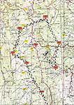
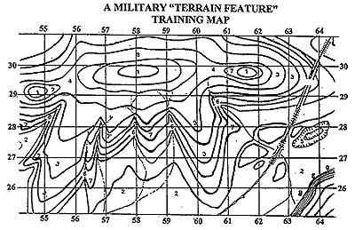
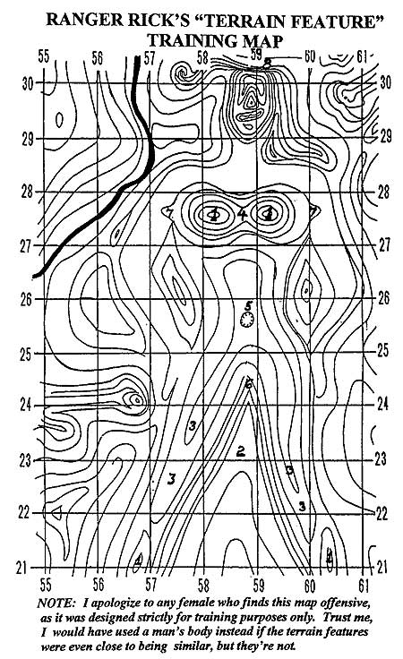
Well to make a long story short.. the students loved the way I taught my classes and today I have a bunch of Bosnian war bayonets hanging up on my wall here at home. And just to show you (for an example) as to how I made my classes interesting and entertaining. Check out these two different terrain feature training maps from my basic land navigation class and then you tell me which one would you prefer to use and learn by.
The point I'm trying to make is this... you don't have to teach things by-the-book if you know a much simpler, easier and entertaining way to teach something. It's called K-I-S-S, which means "Keep It SimpleStupid." And if you can make something simple and entertaining, your students will enjoy your class as much as you.
Terrain Features
| Hill Top - 1 |
Ridge - 3 |
Depression - 5 |
Spur - 7 |
| Valley - 2 |
Saddle - 4 |
Draw - 6 |
Cliff - 8 |
 
Wilderness Survival Skills > Wilderness Survival Tips > Here
|
|